Directory
- Preface
- Effect
- accomplish
-
- Introduce js
- Use in projects
-
- renderings
- introduce
- html
- CSS
- Specific implementation of JS
- Call instructions
-
- When adding
- When modifying
- Determine whether it is within the range
- java painting and determining whether it is within the range
-
- method one
- Method 2
-
- pom.xml dependency introduction
- import introduction
- accomplish
Foreword
AMAP official API: https://lbs.amap.com/demo/javascript-api/example/overlayers/polygon-draw-and-edit
Amap API version: 1.4.15
Use JS to implement polygonal fence settings on Amap (in addition to simple examples, my implementation in the project is also included)
Effect

Implementation
Introduce js
You need to add a security key and a key. The reason why you need to use a security key was officially changed on 2021-12-02. Originally, you only needed the key.
Reference URL: https://lbs.amap.com/api/javascript-api/guide/abc/prepare
Here plugin=AMap.***** is the object you need.
<script type="text/javascript">
        window._AMapSecurityConfig = {<!-- -->
            securityJsCode:'bf5ed************************886', // Security key (official projects officially recommend using nginx proxy to introduce the key)
        }
</script>
<script type="text/javascript" src="//i2.wp.com/webapi.amap.com/maps?v=1.4.15 & amp;key=22d1**************** *******b8 &plugin=AMap.Autocomplete,AMap.PlaceSearch,AMap.PolyEditor,AMap.Marker"></script>
html implementation
<!doctype html>
<html>

<head>
<meta charset="utf-8">
<meta http-equiv="X-UA-Compatible" content="IE=edge">
<meta name="viewport" content="initial-scale=1.0, user-scalable=no, width=device-width">
<style>
html,
body,
#container {<!-- -->
width: 100%;
height: 100%;
}
</style>
<title>Polygon drawing and editing</title>
<link rel="stylesheet" href="https://a.amap.com/jsapi_demos/static/demo-center/css/demo-center.css" />
<script type="text/javascript">
window._AMapSecurityConfig = {<!-- -->
securityJsCode:'bf5******************886',
}
</script>
<script src="//i2.wp.com/webapi.amap.com/maps?v=1.4.15 & amp;key=22d****************** a20b8 & amp;plugin=AMap.PolyEditor"></script>
</head>

<body>
<div id="container"></div>
<div class="input-card" style="width: 120px">
<button class="btn" onclick="startEdit()" style="margin-bottom: 5px">Start editing</button>
<button class="btn" onclick="submitMap()">End editing</button>
</div>
<script type="text/javascript">
\t\t\t
var temp_lnglat = []; // Temporary storage location
var tempMap = {<!-- -->}; // Temporarily store map objects
\t\t\t
//The latitude and longitude of the location to be drawn
var lngLat = [116.400274, 39.905812];
\t\t\t
initMap(lngLat);
\t\t\t
/**
*------------------------------------------------ -------------------------------------------------- ----------
* Initialize map
*/
function initMap(lngLat){<!-- -->
tempMap.map = new AMap.Map("container", {<!-- -->
center: lngLat,
zoom: 14
});
\t\t\t\t
createPolygon(lngLat);
}
\t\t\t
/**
*------------------------------------------------ -------------------------------------------------- ----------
* Create polygon
* @param {Object} paths
*/
function createPolygon(lngLat, paths){<!-- -->
// Draw the longitude and latitude of each corner of the polygon (use this if not available and create a default polygon at the current location)
if(!paths || paths.length < 1){<!-- -->
paths = [
[lngLat[0] + 0.003048, lngLat[1] + 0.014442],
[lngLat[0] + 0.010429, lngLat[1] - 0.008257],
[lngLat[0] + 0.002018, lngLat[1] - 0.013458],
[lngLat[0] - 0.010427, lngLat[1] - 0.014446]
]
}
// Assign to the temporary array (the longitude and latitude of these polygon corners are required when submitting)
temp_lnglat = paths;
//Create painting
var polygon = new AMap.Polygon({<!-- -->
path: paths,
strokeColor: "#0f79d7",
strokeWeight: 3,
strokeOpacity: 0.6,
fillOpacity: 0.4,
fillColor: '#1791fc',
zIndex: 50,
})
tempMap.map.add(polygon)
//Zoom the map to the appropriate field of view level
tempMap.map.setFitView([polygon])
//Edit drawing object
tempMap.polyEditor = new AMap.PolyEditor(tempMap.map, polygon)
\t\t\t\t// event
tempMap.polyEditor.on('addnode', function(event) {<!-- -->
console.log('Trigger event: addnode ----------------------------------------- -')
console.log("Add:", event)
console.log("Add-Longitude:", event.lnglat.lng, "Latitude:", event.lnglat.lat)
})
tempMap.polyEditor.on('adjust', function(event) {<!-- -->
console.log('Trigger event: adjust ---------------------------------------------- -')
console.log("Modification:", event)
console.log("Modification-Longitude:", event.lnglat.lng, "Latitude:", event.lnglat.lat)
})
tempMap.polyEditor.on('removenode', function(event) {<!-- -->
console.log('Trigger event: removenode ----------------------------------------- -')
console.log("removenode:", event)
})
tempMap.polyEditor.on('end', function(event) {<!-- -->
console.log('Trigger event: end ----------------------------------------- -')
console.log("end:", event)
// event.target is the edited polygon object
})
}
\t\t\t
/**
*------------------------------------------------ -------------------------------------------------- ------
* Clear painting
*/
function clearMap() {<!-- -->
tempMap.map.clearMap(tempMap.polyEditor)
tempMap.map.remove(tempMap.polyEditor)
}

/**
*------------------------------------------------ -------------------------------------------------- ----------
* Start editing
*/
function startEdit(){<!-- -->
//Open for editing
tempMap.polyEditor.open();
}

/**
*------------------------------------------------ -------------------------------------------------- ----------
*Submit latitude and longitude
*/
function submitMap() {<!-- -->
// Close painting
//tempMap.polyEditor.close();
// Get all latitude and longitude
if(tempMap.polyEditor.bu){<!-- -->
temp_lnglat = tempMap.polyEditor.bu[0];
}
//Remove the Q and R attribute values and retain the values of lng and lat
temp_lnglat = temp_lnglat.map(function(item, index){<!-- -->
return [item.lng, item.lat];
})
console.log("Get all coordinates:", JSON.stringify(temp_lnglat));
}
\t\t\t
</script>
</body>

</html>
html search tips
<!doctype html>
<html>
<head>
    <meta charset="utf-8">
    <meta http-equiv="X-UA-Compatible" content="IE=edge">
    <meta name="viewport" content="initial-scale=1.0, user-scalable=no, width=device-width">
    <title>Input prompt</title>
    <link rel="stylesheet" href="https://a.amap.com/jsapi_demos/static/demo-center/css/demo-center.css" />
    <style>
        html,
        body,
        #container {<!-- -->
          width: 100%;
          height: 100%;
        }
    </style>
</head>
<body>
<div id="container"></div>
<div class="info">
    <div class="input-item">
      <div class="input-item-prepend">
        <span class="input-item-text" style="width:8rem;">Please enter keywords</span>
      </div>
      <input id='tipinput' type="text">
    </div>
</div>

<script type="text/javascript">
        window._AMapSecurityConfig = {<!-- -->
            securityJsCode:'bf5************************886',
        }
</script>
<script type="text/javascript" src="//i2.wp.com/webapi.amap.com/maps?v=1.4.15 & amp;key=22d**************** *********0b8 & amp;plugin=AMap.Autocomplete,AMap.PlaceSearch"></script>
<script type="text/javascript">
    /**
*------------------------------------------------ -------------------------------------------------- ------
* Render map
*/
function initMap(){<!-- -->
var map = new AMap.Map('container', {<!-- -->
resizeEnable: true, //Whether to monitor map container size changes
});
//Input prompt
var autoOptions = {<!-- -->
input: "tipinput"
};
var auto = new AMap.Autocomplete(autoOptions);
//Construct location query class
var placeSearch = new AMap.PlaceSearch({<!-- -->
map: map
});
// Register for monitoring, which will be triggered when a record is selected.
AMap.event.addListener(auto, "select", selectSearch);
function selectSearch(e) {<!-- -->
console.log(e)
placeSearch.setCity(e.poi.adcode);
placeSearch.search(e.poi.name); // Keyword search query
}
}
initMap();
</script>
</body>
</html>
Use in project
Renderings
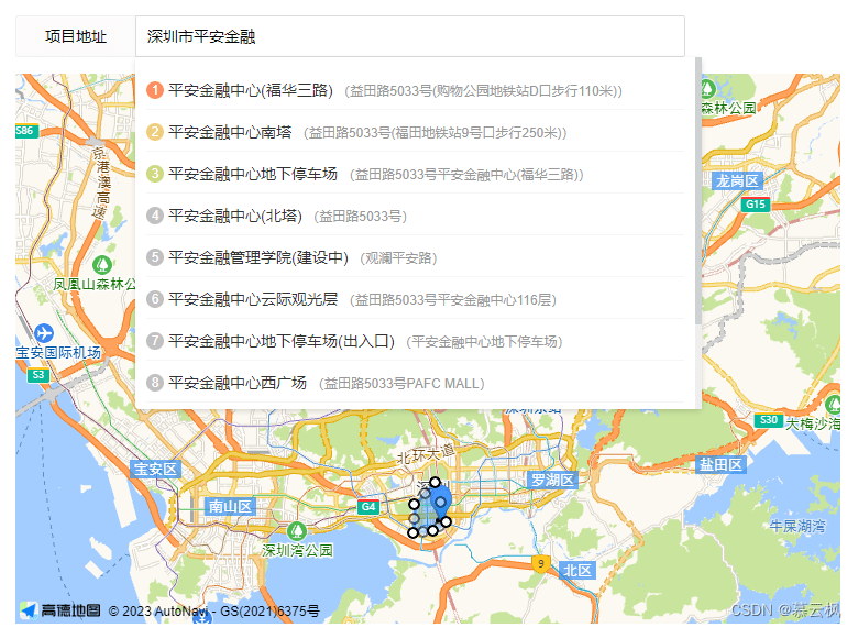
This is what I use in my project (copy and paste is available)
Introduction
Remember to change the security key and key
<script type="text/javascript">
window._AMapSecurityConfig = {<!-- -->
securityJsCode:'bf5e************************886',
}
</script>
<script src="//i2.wp.com/webapi.amap.com/maps?v=1.4.15 & amp;key=22d****************** ****20b8 & amp;plugin=AMap.Autocomplete,AMap.PlaceSearch,AMap.PolyEditor,AMap.Marker"></script>
\t
html
The layui framework is used here, everything is copied directly, only the key is taken.
<div class="layui-form-item">
<label class="layui-form-label">Project address</label>
<div class="layui-input-block" style="width: 500px;">
<input type="text" name="addr" id="addr" placeholder="Enter the address and select details, then operate the map"autocomplete="off" class="layui-input">
<div class="lay-search-content">
<ul></ul>
</div>
</div>
</div>
<div class="layui-form-item">
<!-- map map -->
<div class="container" id="container" style="height: 500px;width: 750px;"></div>
</div>
CSS
The effect of writing it yourself
.lay-search-content{<!-- -->
padding: 10px;
background: white;
border-radius: 4px;
color: #333333;
line-height: 15px;
box-shadow: #00000024 0px 2px 5px 0;
max-height: 300px;
overflow: auto;
display: none;
position: absolute;z-index: 99999;
width: 99%;
}
.lay-search-content li{<!-- -->
list-style: none;
margin: 5px 0px;
padding: 8px 0px;
border-bottom: 1px solid whitesmoke;
cursor: pointer;
}
.lay-search-content li:hover{<!-- -->
background: #f1f1f1;
}
.lay-search-mark{<!-- -->
width: 16px;
display: inline-block;
height: 16px;
background: #c1c1c1;
text-align: center;
line-height: 16px;
border-radius: 50%;
margin-right: 4px;
color: white;
font-size: 12px;
position: relative;
top: -1px;
}
Specific implementation of JS
var temp_lnglat = [116.400274, 39.905812]; // Temporarily store the current position
var temp_fence_lnglat = []; // Temporarily store all locations
var tempMap = {<!-- -->}; // Temporarily store map objects

/**
 *------------------------------------------------ -------------------------------------------------- ------
 *Reset map values
 */
function clearMap(state) {<!-- -->
    if(!state){<!-- --> // No value will be assigned if modified
        temp_lnglat = [116.400274, 39.905812];
        temp_fence_lnglat = [];
    }
    if(tempMap.polyEditor){<!-- -->
        tempMap.map.clearMap(tempMap.polyEditor)
        tempMap.map.remove(tempMap.polyEditor)
    }
}

/**
 *------------------------------------------------ -------------------------------------------------- ------
 * Render map
 */
function initMap(state){<!-- -->
    tempMap.map = new AMap.Map('container', {<!-- -->
resizeEnable: true, //Whether to monitor map container size changes
        center: temp_lnglat,
        zoom: 14,
});
    //Construct location query class
    tempMap.placeSearch = new AMap.PlaceSearch({<!-- -->
        city: "nationwide", // point of interest city
    });
    $("#addr").bind('input propertychange', function() {<!-- -->
        var text = $("#addr").val();
        searchAddr(text)
    })
    clickPosition(temp_lnglat[0], temp_lnglat[1], state);
}

/**
 *------------------------------------------------ -------------------------------------------------- ------------------
 * Map search
 * @return
 */
function searchAddr(text) {<!-- -->
    // For keyword query, just set it as input box. There is name in the set returned below. You can re-query the results and select them yourself.
    tempMap.placeSearch.search(text, function (status, result) {<!-- -->
        // When the query is successful, the result corresponds to the matching POI information.
        console.log("Search result coordinates:", result)
        if (!result.poiList){<!-- -->
            return;
        }
        var pois = result.poiList.pois;
        $(".lay-search-content").css("display", "block");
        $(".lay-search-content>ul").empty();
        for (var i = 0; i < pois.length; i + + ) {<!-- -->
            var poi = pois[i];
            var s = '<li οnclick="clickPosition(' + poi.location.lng + ', ' + poi.location.lat + ')">';
            var index = i + 1;
            if (index == 1) {<!-- -->
                s + = ' <span class="lay-search-mark" style="background: #ff8e63;">' + index + '</span>' + poi.name;
            } else if (index == 2) {<!-- -->
                s + = ' <span class="lay-search-mark" style="background: #edd07d;">' + index + '</span>' + poi.name;
            } else if (index == 3) {<!-- -->
                s + = ' <span class="lay-search-mark" style="background: #cddb82;">' + index + '</span>' + poi.name;
            } else {<!-- -->
                s + = ' <span class="lay-search-mark">' + index + '</span>' + poi.name;
            }
            s + = ' <span style="color: #999;font-size: 12px">(' + poi.address + ')</span>';
            s + = '</li>';
            $(".lay-search-content>ul").append(s);
            var marker = [];
            marker[i] = new AMap.Marker({<!-- -->
                position: poi.location, // latitude and longitude object, or a one-dimensional array of latitude and longitude [116.39, 39.9]
                offset: new AMap.Pixel(0, -20),//Offset position relative to the base point
                title: poi.name
            });
            // [Display content information above the mark]
            var infoWindow = new AMap.InfoWindow({<!-- -->offset: new AMap.Pixel(0, -30)});//Map location object
            // Click to pop up content
            marker[i].content = poi.name;
            marker[i].on('click', markerClick);

            function markerClick(e) {<!-- -->
                var position = e.target.getPosition();
                var content = "<div>" + e.target.content + "</div>"; // Content to be displayed
                content + = "<div style='text-align: center'><a class='layui-btn layui-btn-sm' οnclick='clickPosition(" + position.lng + ", " + position.lat + " )'>Choose to set up a fence</a></div>"
                infoWindow.setContent(content);
                infoWindow.open(tempMap.map, position);
            }
            // Add the created point markers to the existing map instance:
            tempMap.map.add(marker[i]);
        }
        tempMap.map.setFitView();
    })
}

/**
 *------------------------------------------------ -------------------------------------------------- ------------------
 *Search results and choose to set up a fence
 * @param lng
 * @paramlat
 */
function clickPosition(lng, lat, state) {<!-- -->
    $(".lay-search-content").css("display", "none");
    clearMap(state);
    temp_lnglat = [lng, lat];
    //Add point mark
    var markers = new AMap.Marker({<!-- -->
        position: temp_lnglat, // latitude and longitude object, or a one-dimensional array of latitude and longitude [116.39, 39.9]
        offset: new AMap.Pixel(0, -20),//Offset position relative to the base point
    });
    tempMap.map.add(markers);
    tempMap.map.setCenter(temp_lnglat)
    createPolygon(temp_lnglat, temp_fence_lnglat);
}
/**
 *------------------------------------------------ -------------------------------------------------- ----------
 * Create polygon
 * @param {Object} paths
 */
function createPolygon(lngLat, paths){<!-- -->
    // Draw the longitude and latitude of each corner of the polygon (use this if not available and create a default polygon at the current location)
    if(!paths || paths.length < 1){<!-- -->
        paths = [
            [lngLat[0] + 0.003048, lngLat[1] + 0.014442],
            [lngLat[0] + 0.010429, lngLat[1] - 0.008257],
            [lngLat[0] + 0.002018, lngLat[1] - 0.013458],
            [lngLat[0] - 0.010427, lngLat[1] - 0.014446]
        ]
    }
    // Assign to the temporary array (the longitude and latitude of these polygon corners are required when submitting)
    temp_fence_lnglat = paths;
    //Create painting
    var polygon = new AMap.Polygon({<!-- -->
        path: paths,
        strokeColor: "#0f79d7",
        strokeWeight: 3,
        strokeOpacity: 0.6,
        fillOpacity: 0.4,
        fillColor: '#1791fc',
        zIndex: 50,
    })
    tempMap.map.add(polygon)
    //Zoom the map to the appropriate field of view level
    tempMap.map.setFitView([polygon])
    //Edit drawing object
    tempMap.polyEditor = new AMap.PolyEditor(tempMap.map, polygon)
    // event
    tempMap.polyEditor.on('addnode', function(event) {<!-- -->
        console.log('Trigger event: addnode ----------------------------------------- -')
        console.log("Add:", event)
        console.log("Add-Longitude:", event.lnglat.lng, "Latitude:", event.lnglat.lat)
    })
    tempMap.polyEditor.on('adjust', function(event) {<!-- -->
        console.log('Trigger event: adjust ---------------------------------------------- -')
        console.log("Modification:", event)
        console.log("Modification-Longitude:", event.lnglat.lng, "Latitude:", event.lnglat.lat)
    })
    tempMap.polyEditor.on('removenode', function(event) {<!-- -->
        console.log('Trigger event: removenode ----------------------------------------- -')
        console.log("removenode:", event)
    })
    tempMap.polyEditor.on('end', function(event) {<!-- -->
        console.log('Trigger event: end ----------------------------------------- -')
        console.log("end:", event)
        // event.target is the edited polygon object
    })
    //Open for editing
    tempMap.polyEditor.open();
}

/**
 *------------------------------------------------ -------------------------------------------------- ----------
 * Start editing
 */
function startEdit(){<!-- -->
    //Open for editing
    tempMap.polyEditor.open();
}

/**
 *------------------------------------------------ -------------------------------------------------- ----------
 *Submit latitude and longitude
 */
function submitMap() {<!-- -->
    // Close painting
    //tempMap.polyEditor.close();
    // Get all latitude and longitude
    if(tempMap.polyEditor.bu){<!-- -->
        temp_fence_lnglat = tempMap.polyEditor.bu[0];
    }
    //Remove the Q and R attribute values and retain the values of lng and lat
    temp_fence_lnglat = temp_fence_lnglat.map(function(item, index){<!-- -->
        return [item.lng, item.lat];
    })
    console.log("Get all coordinates:", JSON.stringify(temp_fence_lnglat));
}
Calling instructions
Based on the js written above, just copy and call it
When added
initMap();
When modifying
data.lngLat and data.fenceLngLat are the latitude and longitude that we have stored and set.
temp_lnglat = JSON.parse(data.lngLat);
temp_fence_lnglat = JSON.parse(data.fenceLngLat);
initMap(true);
Judge whether it is within the range
Reference API: https://lbs.amap.com/demo/javascript-api/example/relationship-judgment/point-surface-relation
//Create a point (display the current user’s point)
var marker = new AMap.Marker({<!-- -->
map: map,
position: [116.566298, 40.014179]
});
// Determine whether it is within the range
var point = marker.getPosition();
var isPointInRing = AMap.GeometryUtil.isPointInRing(point, paths); // paths are the coordinate arrays of polygons
console.log("Is it within the range:", isPointInRing?'Yes':'No')
java painting and determining whether it is within the range
Method 1
Reference URL 1: https://blog.csdn.net/qq_39190679/article/details/102524601
Reference website 2: https://www.jianshu.com/p/5a2398a84889
Reference URL 3: https://zhuanlan.zhihu.com/p/534997829
package cn.geesuntar.utils;

import com.alibaba.fastjson.JSONArray;

import java.awt.geom.Point2D;
import java.util.ArrayList;
import java.util.List;

public class RegionUtil {<!-- -->

    private static double EARTH_RADIUS = 6378137;

    private static double rad(double d) {<!-- -->
        return d * Math.PI / 180.0;
    }

    /**
     *Polygon
     * @param point The horizontal and vertical coordinates of the point to be judged
     * @param polygon A collection of vertex coordinates
     * @return
     */
    public static boolean isInPolygon(Point2D.Double point, List<Point2D.Double> polygon) {<!-- -->
        java.awt.geom.GeneralPath peripheralPath = new java.awt.geom.GeneralPath();
        Point2D.Double first = polygon.get(0);
        peripheralPath.moveTo(first.x, first.y);
        polygon.remove(0);
        for (Point2D.Double d : polygon) {<!-- -->
            peripheralPath.lineTo(d.x, d.y);
        }
        peripheralPath.lineTo(first.x, first.y);
        peripheralPath.closePath();
        return peripheralPath.contains(point);
    }

    /**
     * Get the distance by latitude and longitude (unit: meters)
     *
     * @param lat1 latitude 1
     * @param lng1 longitude 1
     * @param lat2 latitude 2
     * @param lng2 longitude 2
     * @return distance
     */
    public static double getDistance(double lat1, double lng1, double lat2,
                                     double lng2) {<!-- -->
        double radLat1 = rad(lat1);
        double radLat2 = rad(lat2);
        double a = radLat1 - radLat2;
        double b = rad(lng1) - rad(lng2);
        double s = 2 * Math.asin(Math.sqrt(Math.pow(Math.sin(a / 2), 2) +
                Math.cos(radLat1) * Math.cos(radLat2) * Math.pow(Math.sin(b / 2), 2)));
        s = s * EARTH_RADIUS;
        s = Math.round(s * 10000d) / 10000d;
        return s;
    }

    /**
     * round
     * @param lat1 latitude
     * @param lat2 longitude
     * @param lng1 latitude
     * @param lng2 longitude
     * @param radius Determines whether a point is within a circular area and compares whether the distance between the coordinate point and the center of the circle is less than the radius
     */
    public static boolean isInCircle(double lng1, double lat1, double lng2, double lat2, double radius) {<!-- -->
        double distance = getDistance(lat1, lng1, lat2, lng2);
        System.out.println("Radius:" + radius + "Analysis radius:" + distance);
        if (distance > radius) {<!-- -->
            return false;
        } else {<!-- -->
            return true;
        }
    }

    public static void main(String[] args) {<!-- -->
        String str = "[[114.125986,22.607612],[114.125241,22.607122],[114.125547,22.606775],[114.126303,22.607236]]";
        JSONArray jsonArray = JSONArray.parseArray(str);
        JSONArray jsonArray1 = null;
        List<Point2D.Double> polygon = new ArrayList<>();
        for (Object o : jsonArray) {<!-- -->
            jsonArray1 = JSONArray.parseArray(o.toString());
            polygon.add(new Point2D.Double(jsonArray1.getDouble(0),jsonArray1.getDouble(1)));
        }
        System.out.println(RegionUtil.isInPolygon(new Point2D.Double(114.125872,22.606983), polygon));
    }

}
Method 2
Reference URL 1: https://www.php.cn/faq/584994.html
Reference URL 2: https://blog.51cto.com/u_16175486/6825616
pom.xml dependency introduction
<dependency>
<groupId>com.amap.api</groupId>
<artifactId>amap-java-sdk</artifactId>
<version>1.4.0</version>
</dependency>
import introduction
import com.amap.api.maps.AMap;
import com.amap.api.maps.AMapOptions;
import com.amap.api.maps.CameraUpdateFactory;
import com.amap.api.maps.MapView;
import com.amap.api.maps.model.LatLng;
import com.amap.api.maps.model.LatLngBounds;
import com.amap.api.maps.model.Polygon;
import com.amap.api.maps.model.PolygonOptions;
Implementation
Create a map view object and add it to the layout
MapView mapView = new MapView(context, new AMapOptions());
//layout.addView(mapView);
Initialize map
AMap aMap = mapView.getMap();
aMap.moveCamera(CameraUpdateFactory.newLatLngZoom(new LatLng(39.90923, 116.397428), 10));
Here we can add the set polygon points to the collection
List<LatLng> points = new ArrayList<>();
points.add(new LatLng(39.910698, 116.399406));
points.add(new LatLng(39.909819, 116.405778));
points.add(new LatLng(39.919719, 116.405814));
points.add(new LatLng(39.919657, 116.399362));
Set polygonal painting
PolygonOptions polygonOptions = new PolygonOptions();
polygonOptions.addAll(points);
polygonOptions.strokeColor(Color.RED);
polygonOptions.fillColor(Color.argb(50, 255, 0, 0));
polygonOptions.strokeWidth(10);
Add polygons to the map
Polygon polygon = aMap.addPolygon(polygonOptions);
Here is to determine whether the user’s point is within the polygon range we set.
LatLng location = new LatLng(39.913678, 116.403873);
boolean contains = polygon.contains(location);
System.out.println("Whether the position is within the polygon: " + contains);
The functions applied are probably like this!
Please refer to the circular fence: https://blog.csdn.net/weixin_43992507/article/details/130731955